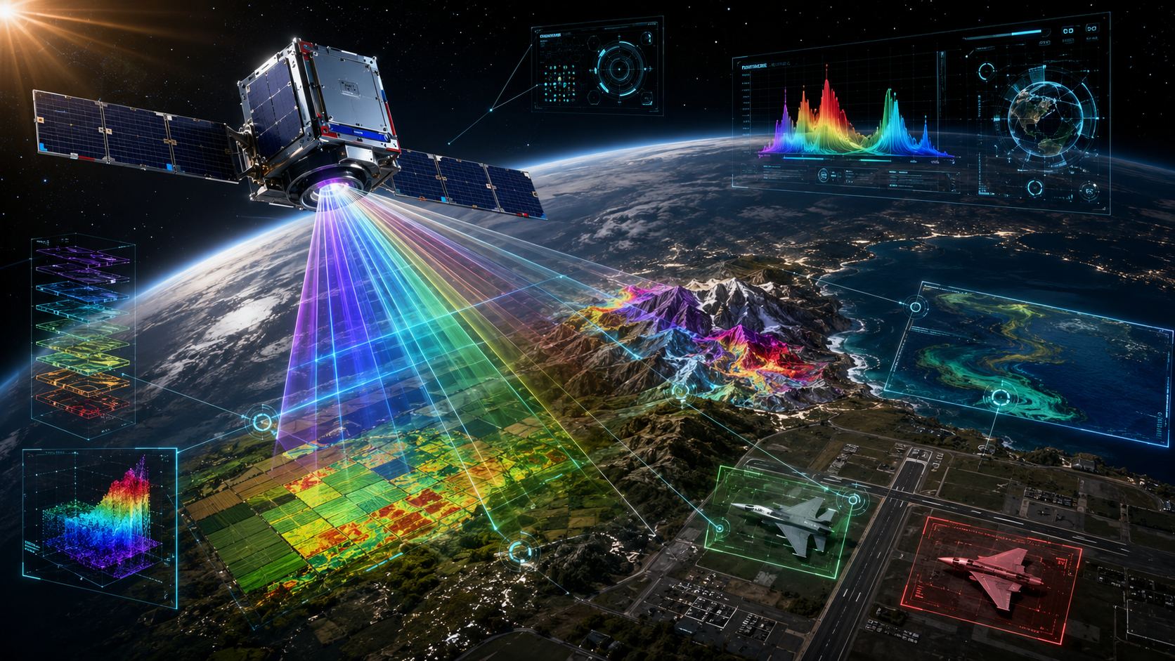
Satellites already see the planet. Orus wants them to understand what they are looking at.
The French New Space startup is developing a constellation of hyperspectral microsatellites designed to read the chemical and physical signatures of materials on Earth from orbit. Not just shapes. Not just colors. Not just radar relief. Actual spectral fingerprints.
That means crops under stress before the eye can see it, minerals without immediate drilling, pollution trails at sea, and, yes, military decoys that suddenly become much harder to hide. The first satellite is expected around 2027, according to public information around the company and its funding round.
Orus is not pitching another pretty Earth-observation camera. It is pitching something closer to a spaceborne forensic scanner.
Table of contents
- What Orus is building
- How hyperspectral imaging works
- Why this matters for defense
- The civilian uses could be just as big
- Why Orus needs AI in orbit
- A French bet in Europe’s Earth-observation race
- Orus and hyperspectral satellites: key questions
What Orus is building
Orus is a French aerospace startup founded in 2024 by Laurent Escarrat and Vincent David. Its mission is to deliver high-resolution hyperspectral space imagery capable of identifying objects and environments by their chemical composition and surface conditions, according to the company’s own description on its official website.
The company’s system, marketed around the HYP4Uses offer, is built around a future constellation of microsatellites. Its first satellite, HYP4U-1, is intended to act as a demonstrator for the broader service.
In June 2025, Orus raised €5 million in seed financing led by Speedinvest, with Région Sud Investissement and business angels also participating. Public information around the deal says the funding is intended to support the launch of the company’s first satellite and the commercialization of its imagery services around 2027.
That timeline matters because hyperspectral Earth observation is moving from research-grade capability into a more commercial, operational market. Agriculture, defense, environmental monitoring, insurance, mining, infrastructure, and public agencies all want faster, more precise intelligence from space. Orus wants to sell them the layer that traditional imagery often misses.
How hyperspectral imaging works
Classic optical satellites are, in simple terms, extremely powerful cameras. They capture reflected light in a limited number of bands, broadly similar to how human vision understands red, green, and blue. Radar satellites do something different: they actively measure surfaces and structures, including through clouds or darkness, by using radio waves.
Hyperspectral imaging plays another game.
Instead of reducing the world to a few color channels, a hyperspectral sensor splits reflected light into hundreds of narrow spectral bands, from visible wavelengths into infrared regions. Every material reflects and absorbs light differently. Vegetation, water, metal, minerals, plastic, fuel traces, gases, and soil types can each produce distinctive spectral signatures.
That is the big leap: every pixel in a hyperspectral image can carry information about what the surface is made of, not only what it looks like.
Laurent Escarrat, co-founder of Orus, has described the company’s goal as detecting and identifying spectral signatures in each pixel, whether they come from gas, minerals, metals, or vegetation. The startup frames this as a multi-sector technology, not a single-use satellite product.
The pitch is powerful because it turns Earth observation from visual interpretation into material identification. The difference is not cosmetic. It is the difference between seeing a green field and knowing whether that field is missing nutrients, running short on water, or already under disease pressure.
Why this matters for defense
The defense implications are obvious, and Orus is not hiding them. The company lists defense and security among its target markets, saying hyperspectral data can help distinguish camouflaged or artificial objects, detect chemical traces, and assess terrain usability.
In modern conflict, visual deception is cheap. Inflatable tanks, plastic decoys, fake aircraft, camouflaged structures, and hidden logistics can waste expensive surveillance time and even more expensive munitions. A normal image may show what looks like a fighter jet on a runway. A hyperspectral scan could, in theory, help determine whether the object has the spectral signature of aluminum, paint, fuel, heat-affected material, or something closer to plastic and fabric.
That does not magically solve battlefield intelligence. Satellites still face limits: revisit time, clouds depending on sensor type, atmospheric correction, resolution, adversarial countermeasures, and the difficulty of turning raw data into reliable conclusions. But hyperspectral imaging gives analysts a new layer of evidence.
Terrain is another major use case. Soil moisture can determine whether armored vehicles can move or get bogged down. In a major conflict, that kind of information is not trivia. It can shape routes, timing, risk assessments, and operational planning.
This is where the technology becomes strategically sensitive. Hyperspectral satellites are civilian enough to monitor crops and pollution, but powerful enough to matter for defense intelligence. That dual-use character is exactly why Europe wants more sovereign Earth-observation capability.
The civilian uses could be just as big
The less explosive part of the Orus story may ultimately be the largest market.
In agriculture, hyperspectral imaging can help detect water stress, nutrient deficiency, crop disease, invasive species, and vegetation health before symptoms are clearly visible. For farmers, insurers, agritech platforms, and public agencies, early detection is the difference between reacting late and managing risk early.
For environmental monitoring, the same spectral sensitivity could support detection of complex marine pollution, forest stress, wildfire residues, soil degradation, and changes in land use. This is particularly relevant as climate pressure turns environmental data into economic data. The state of a forest, a watershed, a coastline, or a crop belt now has consequences for insurance, commodities, public policy, and carbon accounting.
Mining and energy are another obvious target. If spectral signatures can help identify mineral compositions or surface indicators of deposits, satellite data could reduce the need for early exploratory drilling in some contexts. It will not replace geology. It could make exploration smarter.
Orus also points to infrastructure, disaster management, insurance, energy, and finance as potential markets. That last one may sound weird until you remember that Earth-observation data already feeds commodity analysis, supply-chain monitoring, crop forecasting, and risk modeling. If a satellite can see stress in crops before markets price it in, the financial industry will pay attention.
Why Orus needs AI in orbit
Hyperspectral imaging has a brutal technical problem: the data is enormous.
A normal image already consumes bandwidth. A hyperspectral image multiplies that by capturing many more bands for each pixel. Send everything back to Earth all the time, and the satellite data pipeline starts choking. Downlink capacity, latency, storage, processing, and cost all become constraints.
Orus’s answer is to push more intelligence onboard the satellite. Instead of treating the spacecraft like a dumb camera that dumps everything to the ground, the company plans to use onboard processing and AI models to sort, filter, and analyze data in orbit.
That means the satellite could prioritize useful information: anomalies, spectral signatures, changes over time, or mission-specific targets. In theory, this makes the service faster and more efficient. It also fits a broader trend in space tech: satellites are becoming edge-computing nodes, not just sensors.
This is where the Geek’n’Destroy angle gets spicy. The future of Earth observation is not just better glass and better sensors. It is AI models running closer to the data source, compressing the loop between observation and decision.
A satellite that can detect, classify, and filter before transmission is more than a camera. It is an orbital analyst.
A French bet in Europe’s Earth-observation race
Orus is arriving at a moment when Europe is trying to strengthen its space autonomy. The European Copernicus programme already relies on Sentinel satellites and contributing missions to provide environmental and security data. ESA has also been expanding the role of commercial New Space companies in the Copernicus Contributing Missions ecosystem.
That matters for startups like Orus. The company has been linked to European and French space support networks, including ESA BIC Sud France and broader New Space initiatives. Public reporting has also pointed to support from French innovation and defense-linked ecosystems, including France 2030, Bpifrance, the DGA, and the Agence de l’innovation de défense.
The broader signal is clear: hyperspectral imaging is not just a science toy. It is becoming part of Europe’s industrial strategy for data sovereignty, environmental intelligence, and defense readiness.
The “world’s most precise” label should still be handled carefully until Orus publishes full technical specifications, orbital performance data, and independent comparisons. Resolution, spectral range, signal quality, revisit frequency, calibration, and processing reliability all matter. Space is where ambitious claims go to meet physics.
But the ambition is real. If Orus can deliver high-fidelity hyperspectral imaging at commercial scale, France could gain a serious position in one of the most valuable next layers of Earth observation.
The old satellite era was about seeing the planet. The next one is about reading it.
Orus and hyperspectral satellites: key questions
What is Orus?
Orus is a French New Space startup developing hyperspectral Earth-observation microsatellites designed to identify materials and surface conditions from orbit.
What makes hyperspectral imaging different?
Hyperspectral imaging splits reflected light into many narrow spectral bands, allowing analysts to detect material signatures rather than only shapes and colors.
When could Orus launch its first satellite?
Public information around the company points to a first satellite launch and early commercialization target around 2027, though launch timelines can change in the space industry.
What is HYP4Uses?
HYP4Uses is Orus’s hyperspectral imagery service offer, aimed at sectors including agriculture, defense, environment, security, energy, mining, insurance, infrastructure, and finance.
Why does hyperspectral imaging matter for defense?
It can potentially help distinguish real equipment from decoys, detect chemical traces, identify camouflaged objects, and assess terrain conditions such as soil moisture.
How could farmers use this technology?
Farmers and agritech companies could use hyperspectral data to detect water stress, nutritional deficiencies, disease risk, crop types, and vegetation health before visible damage appears.
Why put AI onboard satellites?
Hyperspectral data files are extremely large. Onboard AI can help filter and analyze data in orbit, reducing bandwidth needs and sending back more useful information faster.
Is this financial advice?
No. This article discusses a space technology company and its market context. It is not investment advice and should not be used as a basis for financial decisions.